My panorama workflow

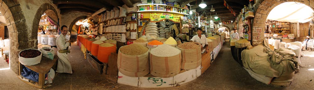
I have had many requests asking about “the making of” the panorama photos I took during my 17-day trip around Sweden this past August. I’m glad to oblige:-)

Equipment:

Hardware:
Nikon D300
Nikon 10.5mm fisheye lens
Manfrotto 055XPROB tripod
360Precision Adjuste panoramic tripod head
2.4GHz 17″ MacBook Pro with 4GB RAM

Software:
Nikon Capture NX
PTGui Pro
Photoshop CS3
CubicConverter
Flash Panorama Player

Workflow:
Taking the shot: When I find a spot, I attach the camera to the tripod and fix the exposure, shutter speed, focus and color temperature so that they are all the same for each series of shots. The panoramic head is set up so that I will take 6 shots of the horizon around at 60-degree intervals and one pointing straight up. The shot pointing straight down is a bit trickier to take — I usually turn on the timer, push the shutter button, then extent the tripod horizontally in such a way that the camera is pointing down from approximately where it was before but without my or the tripod’s legs being in the picture. I usually take more than one shot for each image in a series, and more than one series for a particular location: The former gives me enough backup shots in case objects such as people move between shots; the latter lets me experiment with exposure and shutter speeds to get the best combination.

Processing the shot: Because I try to preserve as much detail from the shoot for as long as possible in my workflow, I use the raw image as my starting point — for Nikon cameras, that’s a .NEF file. I download these to my desktop, then batch process them into 16-bit TIFF files with Nikon Capture NX. The reason I use Nikon’s software here is that it automatically corrects for chromatic aberration (CA) in the fish-eye lens. I find the CA in the raw image to be quite pronounced, but also completely removable when using Capture NX. Photoshop lets you manually correct for CA, but batch processing with Capture NX saves me a lot of time.

Once I’ve chosen the definite six shots around plus one nadir and zenith shot for a particular series, I import them into PTGui Pro and get to work producing the composite panorama. I first let the program have its best go at it with its (very good) automated tools, but then I look over the results and tweak them manually. It is at this stage that a lot of voodoo happens to reduce any visible seams in the image, both by manually choosing good control points on pairs of images and by setting the correct parameters for the optimizer. A lot of the tricks here are just the result of trial and error.

Once a good-looking composite is in place (PTGui lets you preview it), I export the largest possible panorama — an image that is around 11700 by 5850 pixels large. I export to a 16-bit Photoshop .PSB file, which allows for extremely large file sizes. I also turn on PTGui’s option to export all component images as masked layers. The resulting file can be up to 1.5GB large, because it contains the blended base image in the bottom layer plus eight layers for component images, each with a mask attached.

Now I get to work in Photoshop. By removing bits of the mask of a component image layer, I can effectively paint over the base image with the contents of a component image. This makes a difference near the seams, where sometimes a person or moving object at the edge of an image may only be half visible in the blended base image. By choosing to favor one component image over another, I can paint in (or completely remove) an object near the seam.

When such conflicts have been resolved, I export the result as a single-layer 16-bit TIFF file, and open that in Photoshop for some final editing tweaks. It is at this stage that I remove any remaining blending artifacts with the clone stamp tool (for example if straight lines don’t meet correctly), and also apply global exposure adjustments. I save.

Now it is time to create this TIFF file into a viewable panorama. I fire up CubicConverter and import the TIFF file. I then convert it to a series of six cube faces, at the largest possible setting, usually around 3728 pixels square, and then save them into a folder as JPEGs (each around 3MB large). I then create a version with cube faces that are 900 pixels square, and save that into another folder (each around 250KB large). This way I will have one small version for a quick web view, and one full-resolution version for those who want to wait for the full quality view.

There are many different ways of displaying a panorama in a web browser. I have been using Flash Panorama Player, wich is a Flash application that loads six cube-face images and presents them in an interactive viewer. For each panorama, I put a copy of the Flash application, the cube faces and certain helper files into a directory on a web server. This can then be embedded into a web page via a simple <iFrame> tag. Flash Panorama Player is a very versatile tool, and I have used only a small subset of its features.

One feature I would look for in a future implementation of a panorama viewer is the ability to use one full-size panorama image, showing progressively more detailed views as a user zooms in. This way, a quick low-resolution image can be presented at once, but high-resolution images of a portion of the whole panorama can be downloaded and viewed upon zooming without loss of detail.

That’s my workflow. Do let me know if something in the above text isn’t clear or if I’ve rushed it in places.

Panoramas: Getting better technically

I’m in Belgium for two weeks, using the place as a launching pad for two forays into Paris — once to attend a mystery meeting set up by the Chinese government where they will introduce us to their plans for world domination a “virtual” accompaniment to their World Expo in 2010. The other foray will be next weekend, for a meeting at the Centre Culturelle Suèdoise.

In the meantime, I’ve been getting better with the panoramas, at least technically. See if you can find a seam in this one, of De Feestzaal, a new-old shopping arcade in Antwerp. I took it yesterday, played with it today. Still coming up — small versions for those of you sucking internet through straws…

Pandorama's box

For my birthday I got myself a really cool toy that lets you make 360-degree panoramic photos. So far I’ve spent Easter weekend in Belgium making two inside scenes — I’m still a bit unschooled in how to coax out the most detail and fewest visible stiches, but I’m quite happy with my first two attempts.

Here is my grandmother, Mabi, aged 93, in her assisted living home.

And here is my dad in his living room.

In both cases, a new page opens up where you can see the panorama.

Catching up: Kom firin, Ibn Tulun, Berlin, Kuala Lumpur, Sydney, Dubai, DC, Ethiopia, Luxor!

I owe this blog and its readers — what’s left of you — a big apology for not updating since November, but it has been unseasonably busy until very recently. I’ll prove it. The below also serves as a memo to the future: What exactly was I up to late 2007-early 2008? I hope I’ll want to know in 30 years’ time.

Kom Firin: One fine Saturday in October I had the good fortune of accompanying my Egyptologist flatmate Ilona on a visit to an excavation in the Nile Delta: Kom Firin, a Ramesside period tell being excavated by a team from the British Museum, comprises Kom Firin was situated on the front lines with Ramesses II’s mortal enemy, the Libyans. The excavation team also thinks that the Nile once flowed past the site, and that the site possibly was an island.the remains of a fortified settlement and temple complex.

For me the trip was partly wish fulfilment (visiting a “real” archaeological dig) and partly an excuse to play with interesting geo technologies — as reported on Ogle Earth. Kom FirinFlickr photos are over here, and you can see a goereferenced subset on my Google Earth layer (KMZ file, opens in Google Earth).

After a lunch with the team on the porch of the Kom Firin magazine, we drove on to hunt for Kom El-Hisn, another little known site, this one an Old Kingdom settlement from around 3,100 BC. There was very little to see there — no standing structures and no current excavation work — but it was fascinating to see how the old and the new intertwine: there was a village on the edge of the site, and farmland on the other, while Kom El-Hisn itself felt like something of a no-man’s land.

A walk from Ibn Tulun to Zamalek On November 11, a Sunday, I visited Ibn Tulun mosque and the Gayer-Anderson museum, and then walked from there back to Zamalek through popular neighborhoods. Ibn Tulun is perhaps my favorite mosque in Cairo. Ibn Tulun MosqueIt makes room for itself, avoids excessive ornamentation, and its minaret is whimsical, with a circular staircase snaking around the outside of the tower — a structure that would not feel out of place in an Esher print or Borges short story.

The Gayer-Anderson Museum, built against the walls of Ibn Tulun, is a wonderfully restored 17th-century house stuffed with the “Oriental” art collection of early 20th-century British Major Gayer-Anderson, whose residence this was.

From there, I ended up walking home. You can see images from the day on Flickr, but you can also see the walk in the Google Earth layer.

The November-February rapids Then came the rapids. Follow carefully now. Nov 20-28 I was in Stockholm for my work with the Swedish Institute. Nov 28 – Dec 1 I was in Berlin, attending the Online Educa education technology fair. While there I blogged a cool smart board on Ogle Earth:

I also gave a presentation at the Swedish Embassy entitled “Public Diplomacy, Web 2.0 & the 3D Web”. It was all about how we are using social web tools like Facebook and virtual worlds like Second Life to build brand awareness for Sweden:

Then back to Cairo. Petronas TowersFrom Dec 9 – 14 I was in Kuala Lumpur, attending the Global Knowledge III conference. I was invited there to be part of a panel discussion on virtual diplomacy. As it was simultaneously held in Second Life, you can see what it looked like on this YouTube video:

It just so happened that my 20th anniversary high school reunion was being held a few days later, so I found a cheap ticket and headed to Sydney from Dec 15-17. It was the first time in 19 years that I had been back to a city that held many formative experiences for me. My fellow students from Cranbrook School had aged, of course, and it is strange to be in a room with 70 people that are all exactly your own age.

There was also an opportunity to explore the school, Sydney Harbour Bridgeand I also walked all around central Sydney, to our old house on Drumalbyn Road 11, to Bondi Beach (in the rain) to St. Paul’s College at Sydney University (where I boarded for a year), all around Double Bay… It’s as if I was urgently upgrading an outdated mental map of a region of the world I used to know well. I remembered some spots vividly, while often the bits in between had been forgotten, though they’d come racing back when I drove or walked past them.

Then came the long treck back to Cairo. First a night on the Gold Coast (cheap flight, remember?), then a long layover in Kuala Lumpur, and then another long layover in Dubai. In Dubai, however, I checked in to the emirate for the day, took a bus around the city, got off in a nondescript area and walked towards a long line of shimmering high-rises off in the distance. On the way there I stumbled onto a cricket match between Indian and Pakistani bus drivers on a parking lot. It was a surreal setting. Once I had landed on the high-rise strip, Burj DubaiI hailed a taxi and asked him to drive me to the Burj Dubai, the world’s tallest building currently under construction. As the fare was cheap, I had the driver drive me around some more of the landmarks. Dubai is a very very strange place.

I was home again in Cairo Dec 20, but off to Belgium for Christmas with the family Dec 23-30. The highlight (at least for me) was playing with the lego train set I had bought for my niece. Friends Petra and Partrick from Sweden visited Cairo when I returned, and we spent New Year’s at a party on a balcony overlooking the Nile. Nice.

Jan 5-11 I was in Washington, DC, to help set up and inaugurate Virtu-Real, an exhibition that blends the Second House of Sweden in Second Life with the real-life House of Sweden. We got onto Fox News:

picture-4.png

Flickr pictures here, taken with a brand new most excellent Nikon D300, courtesy of a strong euro. Washington DC was also a wonderful opportunity to catch up with old friends — a bunch happen to be living there at the moment.

Then back to Cairo. Jan 13-23 it was off to Ethiopia with egyptologist-flatmate Ilona. Finally, a real vacation, though the pace we set ourselves was a bit grueling. We “only” had 10 days, so we did a lot of flying. A compact itinerary follows:

Arrive in Addis Ababa. Explore the city. Fly north to Bihar Dar, see the Blue Nile, see monasteries on Lake Tana, take the bus north to Gonder, see the fort, Photographing Simien Mountains National Parktake a 4WD north to the amazing Simien Mountains National Park, shoot some baboons (with a camera), back to Gonder, fly via Lalibela (but no stopping!) north to Aksum, see the Axumite stele, drive to Adwa and on to Yeha for an even older temple, then back to Aksum and Fly onto Addis Ababa. Take a bus to the Melka Kunture Prehistoric Site, bribe the guard to open it, see a crocodile, negotiate a private minibus to lake Ziway via the middle of nowhere, see a hippo, then head back to Addis (as they call it) and catch a flight back to Egypt. Phew. But worth it. The only regret is that a religious festival meant there was no way to visit Lalibela. Next time.

Here is the set on Flickr, though you can also see the photos via this Google Map:

Back in Cairo. Then Back in Stockholm Jan 28 – Feb 11, brainstorming this year’s plans for new media work at the Swedish Institute. Back to Cairo! Temple of LuxorFriend Niki came to visit from Stockholm, so for the weekend of Feb 16-18 we headed to Luxor. We’d been tipped off that the best way to see the west bank was to do the walk to the ridge over Queen Hatshepsut’s temple, and we did just that. Such wonderful views. Luxor can be quite trying — not so much the crowds and the hassle, but the fact that there is so much of it. One goes numb. Best to take it in small doses, so I’ll be visiting again soon.

Flickr pics are here. Here they are on a map.

And with that, we’re back in the present.

Cairo: From the Citadel to Ibn Tulun Mosque

How quickly time flies. I went travelling for a chunk of October, to Sweden, the UK and Belgium, got back, was swamped with work, and suddenly it’s November 10…On Sunday, September 30, I went for a walk from the Citadel, which overlooks much of Cairo, eastward through a popular neighborhood until I reached Ibn Tulun Mosque. As always, I’ve traced the route on Google Earth and added to it the photos I took, where I took them. You can also see the photos directly on Flickr.

The Citadel I visited the Citadel out of a sense of duty. Lonely Planet calls it overrated and overpriced, and so have friends here in Cairo. Best to get it out of the way then, as it does impose itself on the city, and hence deserves some acknowledgment.

The tourist entrance is tucked behind the citadel when approaching from the city, so it is not pedestrian-friendly. Dropped off by a taxi, I merged with the herdloads of tourists being disgorged by tour buses. Inside the ramparts, I was indeed underwhelmed — there are abandoned and collapsing barracks and palaces all round, topped by the 19th century Mohammed Ali Mosque. It is the mosque that dominates Cairo’s skyline, and though it is large it boasts an uninspired exterior.

The inside was more gaudy than arabesque. The tour groups didn’t seem to mind as they don’t have much to compare it too, so they spent their few minutes inside recording every precious moment with home electronics. Mohammed Ali Mosque, the CitadelBeing the good self-referential postmodernist that I am, I took pictures of them. If you want large mosques that impress, visit Istanbul instead.

With that mosque out of the way, I had a look at the view. It was essentially the same view as that from the minarets I had climbed previously, but without the Citadel as backdrop, as I was standing on it. So as far as views are concerned, the Citadel isn’t essential either. Look:

But then, through sheer bloody-minded determination, I ventured on until I chanced upon the National Military Museum. This monumental ode to kitsch is a must for all jaded students of world affairs. It takes itself very very seriously, which makes it the best kind of kitsch.

Inside, huge wall-sized paintings portray victorious Egyptian generals being lauded by the populace as they stride confidently into the future. Walking from room to room is like visiting the inner chambers of the mind of a hormonal nationalist. And it is all so very instructive. The Yom Kippur war was conducted by Egypt with “world stunning planning”. The motto alongside one display is “Faith in God, victory or martyrdom”. Witty repartee to the sentiments articulated in these exhibits comes effortlessly, and this can be sustained for hours.

There was one more mosque to see on the way out of the Citadel. An-Nassir Mohammed MosqueThe Qala’un Mosque is spartan next to the ostentation of Mohammed Ali Mosque, but comes with its own distinct sense of humor: If you look carefully, you’ll see that some of the pillars supporting the mosque enclosure have crosses near their crowns. That’s because these pillars were repurposed from conquered crusader forts and monasteries. The guidebooks say that good chunks of he Citadel was constructed by crusader POWs. For the religious fanatic, no doubt few pleasures can top forcing a competing religious fanatic to build your denomination’s places of worship. I sneakily approve.

It was time to head back to the city. Taxis wanted £E20 for any nearby destination (quadruple the reasonable rate) so they were left without anything at all as I headed off on foot.

I took a roundabout way from the Citadel to Ibn Tulun Mosque as I wanted to experience the alleys and passages of the neighborhood inbetween them. My first attempt to transect this densely built part of Cairo ended in a blind alley, so I retraced my steps and tried again.

On several occasions I got my bearings using my Nokia N95’s built in GPS device coupled to Mobile GMaps, which shows high-resolution Google imagery of Cairo downloaded via my local Vodafone 3G data connection. No map of Cairo I’ve seen has the alleys I was in, but Google’s satellite imagery does; the view from above definitely helped at intersections.

Once again, I found myself wishing I spoke better Arabic — not to berate greedy guides but because I wanted to engage with the genuinely friendly people in the shops and stalls, none of whom spoke English. Here I was off the beaten tourist path, so I was more a curiosity than a walking source of revenue.

The most photogenic moments I experienced were alas those where if I had lifted my camera to take the shot, I would have intruded on a moment that was not private but not quite public either. I walked past a barbershop, a miniscule green-walled shop with the fourth wall open to the street, and on the only chair lay an ancient man with his head leaning backwards. A younger man was shaving him carefully, a smile on his face. It was a gentle, touching moment, but I couldn’t stop there and stare. This is a great reason to travel, I think — to experience those moments cameras don’t (or can’t) capture.

Ibn Tulun Mosque Next to Ibn Tulun Mosque is the Gayer-Anderson Museum, which comes highly recommended, but I left it for another day, as it was Ramadan, so it had closed early.Ibn Tulun MosqueI emerged at Ibn Tulun Mosque, a large, severe but beautiful edifice with clean lines and an unusual minaret, with the stairs on the outside. It was getting late in the day, with people soon hurrying home to break the fast, so I only managed a climb up an adjacent minaret to take in the view. I’ll have to start my next walk from here.

A walk through southern Islamic Cairo

Yes, that is a week ago but I lead a busy life here in Cairo.On Sunday, September 23, I traversed the Southern half of Islamic Cairo, from Hussein square down to the Citadel. As always, I’ve traced the route on Google Earth and added to it the photos I took, where I took them. You can also see the photos directly on Flickr.

The walk started at the Al Azhar mosque, home of the sheik who is the spiritual leader of all Egyptian Sunnis (which is a big deal to Egyptian Sunnis, which most are). I then percolated through the back alleys towards Bab Zuweila, the mosque adjacent to the southern gate of the walls surrounding Cairo during the Fatimid era. Further along, I came across the Blue Mosque, one of only few in the world adorned with blue glazed tiles.

Al Azhar Mosque This mosque is the spiritual center of Sunni dogma in Egypt. Upon entering the grounds, I took off my shoes, and was approached by a friendly man offering to show me around in English. I was game for a guided tour.

It began well, with a look at the madrassah, and a walk through the different stages of the mosque’s expansion, but there was also an unexpected proselytising edge to the encounter. Upon learning I spoke Dutch, I was given a booklet in Dutch that purported to show how Islam can be proven scientifically. It was, not surprisingly, a cringe-inducing effort.

20070923161.jpg

There is widespread use of carpeting, and the airy prayer hall is cool and peaceful. So peaceful, in fact, that it is littered with the bodies of men taking Ramadan naps. Women, as everywhere, don’t get to hang out in the best bits of the mosque. The sheik prefers male atheists to devout muslim females, it would seem, though I strongly suspect that this has to do with the fact that femininity is a more visible trait than godlessness. We finally made it into the tomb of the mosque’s founder (a recurring feature of mosques, I later found, and one of the main incentives to build them) where, out of sight of everyone else, my guide made his move. He wanted some money for his services. “I won’t name a price,” he said. Anything I wanted to give would be fine.

I had no problem with that. I offered him 5 LE, the equivalent of a taxi fare.

Ah. Well. He looked at the proffered bill, twisted his faces into a grimace, looked really unhappy, and said, “that is only five pounds.”

I happen to know by now what five pounds (USD 0.90) buys. The cleaning lady gets 40 pounds for 5 hours of work. I was being played and above all I felt resentful at being subjected to the hypocrisy of an apparently pious man who just five minutes ago made a serious effort to bring me into the Muslim fold now deciding I was stupid enough to hit up for a cash windfall — for personal gain, mind you.

I also had a sense of proportion, however. As a westerner, this is little money, so I told him that I was willing to give more if we could call it a contribution to the mosque, and that I could give it to somebody official. That made him quite sheepish, and in the end I gave some money to the old guardian at the entrance. Yes, it occurred to me that this might be his plan B in the great tourist-milking conspiracy.

The back alleys to Bab Zuweila are quite remarkable. They are, above all, garbage-strewn, but not in a negative way — at least not if you’re just passing by once. I often found myself pausing at the signs depicting the names of alleys. I now know half the Arabic alphabet, so more and more I can recognize and read fragments in names. Cairo is turning into a huge mathematical puzzle, wherein I get to apply transformational rules to one set of symbols on billboards and street signs in order to try to convert them to a set of symbols I already know — the latin alphabet. Frankly, learning Arabic is great fun, and addictive.

Bab Zuweila This mosque is being renovated, and here too a guardian offered to show me around. He was more businesslike, however, perhaps as I was the only visitor: He named his price, and also advertised the goods on offer; for 20 LE, I could go up to the roof of the mosque.

20070923175.jpg

Bab el Zuweila is quite pittoresque, but even more so is the view — the twin minarets straddling the gate are real masterpieces, and from the roof you can frame them beautifully. It was the best view of Cairo yet — but only because I didn’t know about the view I’d get from the Blue Mosque, just down the road.

Blue Mosque This is a mosque in disrepair, though it is being renovated with ample funds from UNESCO and others. 20070923216.jpgIt has a rogue palm tree in its central courtyard, which made for an obvious photo op. Here too a guardian offered to show me around, though he was quite well dressed and made out to be some kind of official minder of Egyptian cultural patrimony. And he was unfailingly polite and friendly.

The carrot he dangled in front of me was also quite special: A climb to the top of the 76-meter high minaret for a 360-degree view high of Islamic Cairo. It proved to be one of the more memorable Cairo experiences to date. I took some shots in quick succession and later stitched them together inexpertly, though the resulting jumble is quite accurate in an impressionistic way, if you get my drift:

This is when he decided to ask me, out of the blue, whether I had a wife and children. The reason he asked, it turns out, is that it allowed him to segue to the fact that that he had recently had triplets, and that the youngest, a boy, wasn’t doing to well. He just left that hanging there.

After descending from the minaret, it was time to see the founder’s tomb, which appears to be the preferred place in mosques to make one’s pitch for money. Being the good pavlovian that I am, I offered him 10 LE, which still resulted in an unhappy face. And then he brought his unhealthy triplets into it. What to do?

I gave him more in the end, but made it clear I was unhappy. I resent having insufficient information to be able to decide whether I am being take for a ride or whether the suffering is real — and even then, am I paying for a service or alms? Next time I visit (and I will, as this is something I want visitors to see) I will either do the negotiating beforehand, or stick to my own sense of what the tour was worth, and polite protestations be damned. I took me three mosques to (re)learn my lesson: In Egypt, tourists are for fleecing. I can’t wait to learn Arabic properly to better parry the onslaught.

Coptic Cairo

My Ramadan resolution this year is to see a new neighborhood of Cairo every weekend. Yesterday was Coptic Cairo’s turn, a minuscule walled clump of houses a little to the south of central Cairo that houses a Christian enclave.

The biggest draw there is the Coptic Museum, which had already closed when I arrived in the early afternoon, on account of Ramadan. (The guards are Muslim, and Cairo office hours tend to shorten during this month.) I’ll need to go see that next time there is a visitor. In the meantime, I went for a walk down the back alleys and the poorer end of the cemetery. As always, it’s where the tourists stop going that the (albeit decrepit) charm begins.

1387014199_44e7407f77_m.jpg

Almost all the religious iconography revolves around St. George and the unfortunate dragon he slayed — each depiction tackier than the rest. He also seems to have been tortured rather gruesomely — how gruesomely exactly is driven home by an elaborate display of iron shoes with spikes pointing upwards and a rack, proudly displayed by the local church guardian.

The Orthodox cemetery was perhaps the place with the most character, a very serene place away from the typical Cairo bustle. But I’ll let the photos speak for themselves. Also, see the path I took (and the photos) in Google Earth: Just download this file and open it in Google Earth; it contains all my georeferenced content for Cairo. (No Google Earth? See the content in Google Maps instead.)

Catching up: Summer 2007

This blog has not been fulfilling its purpose of late: To let people know what I have been up to (and to remind myself in my twilight years). This post should redress that.It’s been quite a summer.

Cairo & Whale Valley Early May still saw me in Cairo, where the pressure was on to get the Second House of Sweden — Sweden’s virtual embassy in Second Life — up and running in time for an inauguration that kept on being pushed forward, to accommodate the schedule of Carl Bildt, Sweden’s foreign minister.

It would all end well, but that this would be the case was not at all clear from Cairo, nor was it from Stockholm, so there were many long days and nights, at home and — when the bandwidth demanded it — from internet cafés around Cairo’s Zamalek island.

The highlight of my time in Cairo during May was without a doubt a visit to Wadi Al-Hitan, aka Whale Valley. A shallow wind-eroded valley 3 hours’ driving into the Sahara southwest of Cairo, it holds around 400 mounds of fossilized whales, beached at the edge of an ancient sea 40 million year ago just as they were turning from land-based mammals back into ocean-going vessels. The site is unique because some of the whales found there still had hind legs, turning them into Exhibit A of missing links, evidence of evolution in progress.

Whale Valley has long been a semi-secret, inaccessible to all but the determined adventurer (or vandal). You’d have to hire a couple of sturdy 4WDs and drive through the dunes, aiming for a specific coordinate. In 2005, the site made the UNESCO World Heritage listing; this year a road was built to it, guards were posted and the area cordoned off. For me, this meant it was time to pursue some of the best paleotourism this side of Jurassic Park.

The easiest way there was to hire a car and a driver who knew where we were going. It cost us $120 for the whole day, divided by me and three co-travellers, friends I had rustled into going along.

The route to Whale Valley took us through the heart-shaped El Fayyum, a fertile depression first irrigated by the ancient Egyptians, and where farm technology still owes much to that time. In El Fayyum we also picked up an escort of army recruits, as we had an American in our posse and the area is described as “restless”, whatever that means — the running joke among expats is that the escorts are the ROI Americans get on their billion-dollar aid packages to Egypt.

Whale Valley itself is unlike anything I’ve seen before. The landscape is windswept; rounded bulbs of harder stone jut out of fine yellow sand, and every so often a low mound is crowned with a whale’s fossilized spine, all in a jumble, unless it’s been reconstituted by passing paleontologists.

20070512072.jpg

I’ve never seen fossils so accessible or so close up in their natural environment: Most of the site hasn’t been excavated, so you really get to experience the sense of excitement paleontologists must feel when they first chance upon a new specimen, just lying there. All my previous encounters with objects paleontological were in museums. Whale Valley is a completely different experience.

That’s not to say you get to rummage about by yourself while there. A friendly but unobtrusive park ranger walked with us for nearly two hours, pointing out the most interesting places. There is now a cordoned path through the park, and the ranger was adamant we not veer off it. A few months later, Whale Valley was in the news on reports that two jeeps from an unidentified European diplomatic mission allegedly drove over one of the whale fossil mounds after ignoring orders to stop. It was later revealed the diplomats were from Belgium(!) My Flickr set subsequently got a lot of hits as Whale Valley entered mainstream consciousness. For better and for worse, then, we Belgians have done more than any other nationality to put this place on the map…We were happy to oblige.

I took a good set of photos on the day, and used the expedition to play with some new GPS toys. Here’s the Flickr set, and here’s the post on Ogle Earth. I’ve also updated my Cairo KML file with the track we took on the day.

Second House of SwedenI travelled back to Sweden on May 20, and we launched Second House of Sweden on May 30. Carl Bildt was at the press conference, and it was very well covered by international media. As far as bangs for bucks goes, Sweden definitely got its money’s worth.

The presentation itself was a bit audacious: We sat in front of a big screen; on it was projected my avatar’s view of the virtual embassy. At the embassy in Second Life, the auditorium showed a live video feed of the proceedings at the real-life press conference, with a good number of avatars present. This created wonderful feedback loop opportunities, of course. At one point, press photographers were craning to get a shot of Carl Bildt, his avatar on the screen behind him, and the in-world screen behind his avatar showing the real-world press conference.

The whole thing has been put on Google Video, of course: The inauguration ceremony proper,

and my guided tour:

Check out the blog (Building the) Second House of Sweden for more.

West-coat vacation: In early June I took three weeks of vacation. I travelled to San Francisco, where I attended the International Symposium for Digital Earth at Berkeley. I was there both as blogger for Ogle Earth and as representative for International Polar Year, helping to coordinate the creation of www.ipy.org’s Google Earth layer. It was also an opportunity to catch up with some old friends in the area.

F & M turned up, on their way to a house in the Napa Valley, and I hitched a ride with them. In the Napa valley we ate and drank to excess, much like the movie Sideways though without the self-loathing and the naked running around (at least as far as I am aware).

A few days later, Another M showed up in a rented SUV, and we drove up the west coast of California and into Oregon on the way up to K’s family compound in the hills outside Portland. On the way, the major highlights were the DSC_0129.jpg

Redwood forests and Crater Lake. You can see that set here, or else take a look at it here:

View Larger Map

The redwood forests were impressive but one little run-in with a redwood was especially iconic. I remember this from old National Geographic magazines: A tunnel wide enough for a car to pass through it had been carved through a tree. We found it, did the deed, and documented it. Driving through the tree felt like participating in America’s twin obsessions simultaneously — cars and nature.

After a week in Oregon I travelled to New York for a few days, to touch base, before heading back to Sweden. July and August were spent there, where summers are best. Early September I travelled back to Cairo, where a spare bedroom awaits visitors.

Brian Teed, an old friend from my days in Oklahoma as a camp counselor, has already dropped by — here’s his blog post on the visit.

Western influences on Egypt: A data point

I’m back in Egypt after a summer break in cool Sweden. More about all that later. Meanwhile, check out this little screen capture from Facebook. It’s the “top books” discussed by members of the Egypt group on Facebook:

Granted, it’s a bit of a self-selecting, early-adopter crowd over on Facebook, but still: Alarmists who see a resurgent Islam beating back western influences need to explain the many cases where the influence is clearly flowing the other way.

I am still convinced that the resurgence of Islamism in many parts of the Muslim world is not just due to a perceived sense of rising western influence, but an actual rise in western influence. It’s partly a defensive reaction, rather than the preëmptive action many in the west make it out to be.